VOR Navigation
Part II
- Determining a course to take you direct to a VOR.
- Intercepting and tracking radials inbound and outbound from a VOR.
- Identifying an intersection.
- Determining the Wind Correction Angle that will keep you on course.
- Where on earth am I?
You normally will encounter the first case immediately after takeoff. The procedure is simple. After tuning and identifying the station (Click center-portion of radio face), rotate the OBS until the left-right needle is centered and the TO-FROM flag shows TO. The number that now appears under the OBS index is your course to the station (inbound). It will always be the reciprocal of the radial you are on.
Now turn to and fly that heading, applying drift correction as necessary to keep the needle centered, and that's all there is to it.
Setting the Nav Receiver and VOR
The proper time to tune your Nav receivers is while the aircraft is on the ground. Don't need to be fumbling about after take-off, looking at the Nav receiver or VOR indicator, when you should be concentrating on your climb-out and your turn to the outbound heading. So include tuning the Nav receivers, along with the ADF, in your pre-take-off checklist. That includes setting the OBS to the desired radial.
I've set the Nav Radios, but the TO-FROM flag is still off. What's wrong?
Well, nothing is wrong, actually.
Microsoft, in their "as real as it gets" approach, doesn't allow a VOR to indicate until the aircraft is 1000 ft or so above the ground, unless the VOR station is located at the departure airport. VORs operate in the VHF band, "line of sight," and therefore their signals can not be received until attaining a certain altitude above the ground.
The solution is to turn on the "ident" feature of your Nav receiver, so that you will be able to hear the VOR's Morse-code identification. Take off with everything properly set, and when you hear the Morse ident, or shortly afterward, you have gained sufficient altitude for reliable reception. The VOR's To-From flag should appear. Then, verify by its code that the proper station is tuned, and turn off the ident.
Take note, though, of the published range of the VOR, which FSNavigator displays when the cursor is placed on the VOR. If you're out of range, you won't pick up the VOR signals, and the To-From flags will not appear.
You may also have noted that while on the ground the ADF indicator usually jumps to life when that radio is tuned to the correct frequency, even if the NDB is 25 NM away. That, too, is proper, because the LF radio waves of an NDB propagate differently than VHF, and can be received while the aircraft is on the ground.
Great Barrington Airport to Chester VOR, KGBR to CTR VOR
The first flight will be from Great Barrington, Mass. to the Chester VOR, 21.2 nm distant. Chester VOR is 115.10 MHz. Tune the Nav receiver to the CTR VOR before takeoff and turn on the ident switch to permit hearing the Morse code identifier when the Omni is received (Click center-portion of radio face). Depart from Runway 11 and climb to 5500 ft. After receiving and verifying the ident signal (Click center-portion of radio face) rotate the OBS until the needle centers and the TO-FROM flag is in the TO position. The flag may not appear until a few seconds after hearing the ident.
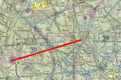
Great Barrington Airport to Chester VOR. Click image for full size.
Turn to the heading shown on the VOR index card and fly to the station, keeping the needle centered with only an occasional correction of heading, if needed. Don't chase the needle! Monitor the Nav Trainer's digital heading readout to more accurately set and track the radial.
As the aircraft nears the Chester VOR the needle will become more sensitive and may swing farther off center. Continue to resist the urge to chase the needle. Maintain the correct heading until station passage, indicated by the TO-FROM flag switching to the FROM position.
Repeat this flight once more, then reverse to runway 29 for another two flights. Fly this route twice more from Rwy 29, but set in a 24 kt wind from 005° to practice tracking a radial with a crosswind. Follow the same technique of "bracketing" that you used for NDB flights.
Cortland County – Chase Field, N03, to V423 Outbound from Ithaca VOR
This flight originates at Cortland County – Chase Field, New York, N03. The flight plan requires intercepting the V423 airway outbound from the Ithaca VOR and then continuing en route for ten minutes.
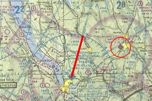
Cortland County Airport to Ithaca VOR, V423 outbound. Click for full size.
V423 is an FAA-designated airway. The "V" preceding the airway number signifies that it is a VOR airway connecting two or more Omni stations. Examine the chart and note that V423 is 026° outbound from the Ithaca VOR. If you had the actual N.Y. Sectional chart you would note that this segment of V423 runs 41 nm from the Ithaca VOR Northeast to the Syracuse VOR.
The procedure to intercept an outbound radial is:
- Before takeoff, set the Nav receiver to the appropriate VOR frequency.
- Similarly while still on the ground, set the OBS to the radial intended to intercept.
- On takeoff, turn to the heading set into the VOR. Since we are intercepting an outbound radial, the heading and the OBS setting should match.
- The TO-FROM indicator should settle on FROM. If it doesn't then continue on the OBS heading until the FROM flag appears. Be aware that the TO-FROM flags won't appear until reaching the minimum reception altitude.
- Where are you in relation to the desired intercept radial? The CDI, left-right needle, will tell you. If the needle is centered, with a FROM flag, you are already dead-center on course. Rather unlikely, though.
- If the needle is to the left, turn left to intercept the radial. The amount of turn depends on how much needle deflection is showing. A large needle deflection warrants a large intercept angle, perhaps 30°. A small needle deflection requires a more modest interception angle.
- A needle deflection to the right requires right turns to intercept.
- Once intercepting the radial, return to the OBS heading and check for any wind correction needed to properly track the radial outbound.
This flight departs from Cortland County Chase Field, N03, Runway 24. Before departure set the Nav receiver to the Ithaca VOR, 111.80 MHz., and the OBS to 026°.
Your cruise altitude will be 5500 ft. Takeoff and maintain runway heading until 2000 ft. Then turn right to 340°. This will give you a 45° intercept angle with V423. It will take seven or eight minutes before you note movement of the VOR needle with a 90 kt climb. As the needle nears the center of the gauge, turn right to 026° for the intercept. Correct your course as necessary to center the VOR needle and to keep it centered.
After intercepting V423 continue your climb to 5500 ft and fly en route for at least ten minutes confident that you are properly maintaining track. Repeat this outbound intercept flight two more times. Then fly the route another two times after setting in an 18 kt. wind from 090°.
Enjoy the flights.
Kingston-Ulster Airport to Albany VOR, 194° inbound
20N to ALB VOR, Landing KALB
It's time to move from practice examples to an actual flight. On this flight we intercept and track a VOR radial inbound to the station.
When you are tracking a radial inbound to a station, you are actually flying in the opposite direction of the radial. Remember, all radials are outbound from a VOR. Suppose that you must track inbound on the 073° radial of the Busybody VOR. Since the 073° radial is outbound from the station and you are flying inbound, you must determine the reciprocal of the radial to properly set the OBS on the VOR indicator.
The reciprocal, of course, differs from the radial by 180°. Don't reach for your calculator to determine a reciprocal. Use the 200–20 method. With this method, you'll accurately determine the radial in less time than it takes to pick up your calculator and turn it on.
You either add 200 then subtract 20 or subtract 200 then add 20. Two examples will show you how easy this is.
Let's go back to tracking inbound to the Busybody VOR on the 073° radial. Add 200, we have 273°. Subtract 20 we have 253°—which is the reciprocal.
In that case we added 200 then subtracted 20. It can't be the other way around, subtract 200 and add 20, because the answer is impossible. Consider: subtract 200 from 073°, we have –127°. Add 20 brings this to –107°, an impossible answer since it's negative.
The second example, track inbound on the 345° radial. First, subtract 200 which gives 145°, then add 20 which gives 165°—the reciprocal, fast and accurate.
Now the flight.
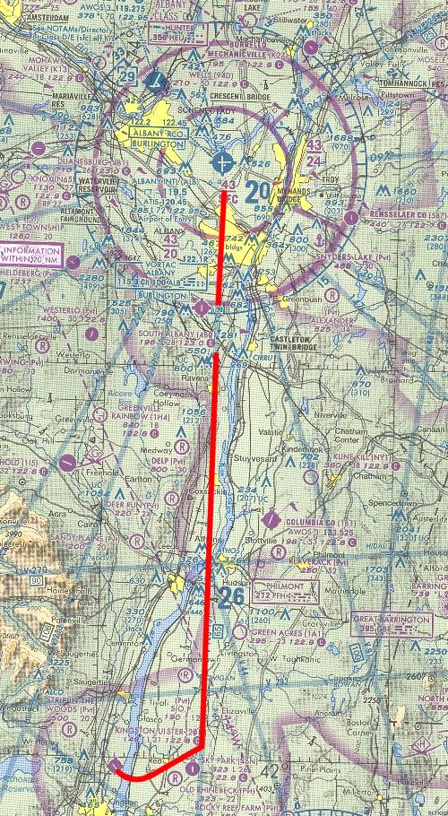
Kingston-Ulster Airport to Albany VOR, 194° inbound. Click for full size.
The flight begins on Rwy 15 of Kingston-Ulster airport in Kingston, New York. Tune your Nav receiver to 115.3 MHz for the Albany VOR and set the OBS to 014°. Cruise altitude will be 3500 ft. After takeoff, turn left to 060° to intercept the V123 Airway. This route will take you to Albany alongside the Hudson River a good part of the way.
You will intercept V123 about five to six minutes after lift-off from Kingston-Ulster Airport. This is a 46 nm flight and we will enlist the aid of the DME to signal when to begin our descent. Make sure that the DME is switched to Nav1. It should show the distance to Albany VOR as soon as there is a needle deflection on VOR1.
When the DME reads 11.0, begin a 500 fpm descent, maintaining 110 kts. When you are comfortably close to the Albany airport and Runway 01 is clearly in sight, slow your speed, set up your landing configuration, and land. Field elevation of Albany Airport is 285 ft.
Enjoy a cup of coffee in the pilot's lounge on the completion of the flight.
Repeat this flight with a 25 kt. wind from 100°.
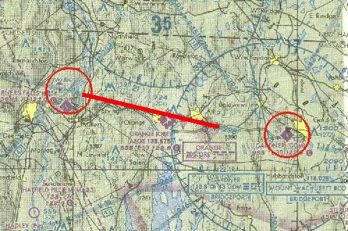
Reporting an Intersection, KGDM to KEEN
An intersection is the point where two or more designated VOR radials cross. Sometimes the combination of a VOR radial and a specified distance along that radial defines an intersection. There is no ambiguity on an intersection location. Intersections are often named, but not always.
Performing some action at an intersection is a commonplace piloting event. It may be a shift in course along a Victor airway, a point of departure to begin an instrument approach, or it could simply be a required or requested position to report to ATC.
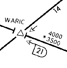
Intersections are identified on both Sectional charts and IFR enroute charts. The illustration below shows the difference in presentation of intersections on those charts, with WARIC intersection the example.
The intersection of the 298° radial from the Gardner VOR and the 238° radial from the Keene VOR defines the WARIC intersection.
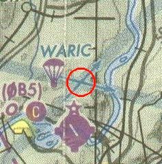
Named intersections, for example WARIC in the left illustration, are identified on Sectional charts by two (or more) crossed arrows pointing towards the VORs that form the reference for that intersection. The parachute symbol here has nothing to do with the intersection; it pertains to nearby Turners Falls airport and cautions of that activity in the area.
The right-hand illustration shows the format for an intersection on an IFR enroute chart. A triangle denotes an intersection. Note also that the two arrows point away from the VORs. The "21" in the box is the distance, in nm., from the Gardner VOR. That box signifies that the intersection may also be established by the 238° radial from the VOR plus a DME (Distance Measuring Equipment) fix at 21 nm.
The "14" in the upper right designates the 14 nm. distance between WARIC and the Keene VOR. The *3500 denotes the minimum obstruction clearance altitude, MOCA, and the 4000 denotes the minimum en route altitude, MEA.
Assume that you are flying outbound from Gardner VOR on the 298° radial. ATC has requested that you report arrival at the WARIC intersection for further clearance. If your aircraft has two Nav receivers, tune Nav-1 to Gardner VOR, 110.6 MHz. Set the OBS to 298°. Tune Nav-2 to the Keene VOR, 109.4 MHz., and set that OBS to 238°.
Flying outbound from Gardner, heading 298°; when the needle on Nav-2 centers, you have arrived at the WARIC intersection. Both VOR indicators will display FROM flags.
How do you know whether you have passed an intersection before you set up the two Navs? It's easy. When the "side" radial is set in the OBS, you have not arrived at the intersection as long as the needle is deflected toward the station, or to the right in this case.
If you had tuned in Keene VOR, set the OBS to 238° and the needle deflected left, you've already passed WARIC, and you better let ATC know it fast.
Only have one Nav receiver? All of the above still works, just takes a little more fiddling. After you are outbound from Gardner and are comfortable that you are accurately tracking the 298° radial, switch on the autopilot and activate the heading hold function. Now retune the Nav for the Keene VOR, reset the OBS to 238°, and monitor the CDI needle. It's worth a quick look back to the Gardner VOR on occasion to be certain that you are accurately tracking outbound on the 298° radial. Don't dwell there else you may pass the intersection.
Now the flight
Gardner Muni Airport to WARIC Intersection. Click for full size.
You have been cleared to depart Gardner, Mass. Muni Airport, KGDM, Runway 18. Turn due west on takeoff then intercept V2 westbound, the 298° radial of Gardner VOR. Report WARIC intersection for further clearance by pausing Flight Simulator and ending the flight.
Before departure, set Nav-1 to Gardner VOR, 110.6 MHz., and set the OBS to 298°. This will be a single-receiver navigation problem. WARIC intersection is the 238° radial of Keene VOR, 109.4 MHz.
Gardner field elevation is 955 ft. ATC has cleared you to 6000 ft.
Repeat the flight with a Runway 36 departure from Gardner. Turn left on departure to 270° and maintain that course until you intercept V2 westbound. Then follow V2 to WARIC Intersection. On reaching WARIC Intersection you are cleared to intercept V93 inbound to the Keene VOR, 109.4, on the 238° radial (Set your OBS to 058°). Reduce altitude to 3000 feet for the leg to Keene.
We will use the DME as an aid on when to again descend. When the DME reads 4.0 on the way to EEN VOR, further descend to 2000 ft and reduce speed to 90 kts. At EEN VOR turn left to about 025° to land at Dillant-Hopkins Airport, Keene, N.H., elev. 485 ft. You are cleared for a straight-in approach on Runway 02, 5.3 nm. from Keene VOR on the 022° radial outbound.
Determining the Wind Correction Angle that will keep you on course
This section will be a review for those who diligently worked the NDB portion of this tutorial. This is the situation that you will use most frequently if you set a wind in your flight simulator for your flying challenges: figuring out the proper Wind Correction Angle, WCA, or "bracketing the course."
If you always take immediate corrective action when you notice the left-right needle drifting off center, you'll never get off course far enough to need bracketing; but a sharp turn over the VOR or vectors to a new radial where the wind effect is unknown, may find you chasing a CDI that's off scale.
The first thing to do is to turn 30° towards the radial and wait for the needle to center. For example, in the last flight with a runway 36 departure from Gardner Muni Airport, turn left after exiting the traffic pattern to intercept the 298° radial. Since we want to intercept quickly, establish a 30° intercept angle with a heading of 268° and then track the 298° radial when the needle centers. With a crosswind, you'll soon notice that the CDI is drifting off center.
Assume the wind has blown you to the left of course—the needle is to the right of center. Here is the procedure for the example flight from Gardner to determine the Wind Correction Angle to accurately track the 0298° radial.
- Begin the bracketing procedure with a turn to 328°, which is the 298° desired track plus a 30° first-try bracket correction.
- This should move the needle back to center. Since it moved the CDI back to center, you now know the WCA bracket: 30° is too much and 0° is not enough.
- Try something in between, so with the needle centered, cut the wind correction in half—to 15°. Your heading should now be 298° + 15°, or 313°.
- Evaluate the effect of the 15° WCA. Depending on whether the plane still drifts away from the radial, add more correction; if it drifts toward the radial, decrease the WCA.
- Continue this cut-and-try process until the CDI stays nailed dead-on in the center.
- The procedure sounds complicated, but is very intuitive. Do it a few times and it becomes second nature.
Click on the VOR Navigation - Part III button for more VOR procedures.
Site best viewed at 600 × 800 resolution or higher.
© 1999 – 2008, Charles Wood.