VOR Approaches
Part I
In aviation, a lack of planning can often result in undesirable consequences.
As the name implies, VOR approaches are approach procedures which use VORs as the primary navigational aid. This section is the first of two that describes VOR instrument approaches. First will be approaches where the VOR is located away from the airport and Part II covers approaches where the VOR is located on the field. This is the same classification system that was used with the NDB approaches that you studied earlier.
Variations of each fundamental type of VOR approach are described and you will fly them all. Seven practice flights cover the most commonly encountered VOR approaches.
A flight-information package is associated with each flight. It is a zip file containing the text description of the flight, a GIF file of the appropriate portion of the IFR chart, and a GIF file of the approach plate for the designated runway at the destination airport. Simply click on the image showing the route of flight to download the information file.
Both the IFR charts and the approach plates were scanned at 300 dpi, so keep that in mind when sizing them to print. In general, you won't go far wrong with one-inch (2.54 cm) left and right margins.
Before you fly the flights study the text descriptions, the approach plates and the IFR charts that you downloaded. By doing this you will find that the procedures fall right into place. Keep the information packages near your computer when you fly the flights, too, so that you can easily refer to them for specific details. After you print the information packages file them in a three-ring binder, otherwise clutter can build fast.
VOR approach procedures are nearly identical to the NDB approaches discussed earlier. If you progressed through those sections then transitioning to VOR approaches will be simple. The VOR gauge indications will differ from the RMI, of course, and some fiddling of the OBS will be necessary, except when on a Localizer approach.
This section concentrates on VOR approaches where the VOR is located off the field.
If you jumped to this point of the website without proceeding through the earlier sections, I strongly recommend that you return to the Air Navigation section and review the sections on VFR Sectional Charts, IFR enroute low altitude charts, and the basics of plotting a course. Further, you should go to the NDB Approaches/Approach Plates section and read the basics of Instrument Approach Plates, now called Terminal Procedures.
Don't chase the needle!
Oh, are you going to grow to hate that expression. It was used often in the NDB sections, and you will see it used frequently through-out the VOR sections, too.What does "Don't chase the needle mean?" Well, consider Roger Rudder's piloting technique. He's tracking the VOR and the needle drifts a dot to the right. Ole eagle-eye Roger notices, and following the maxim "always steer towards the needle" slams the stick to the right. The sound of breaking glass comes from the passenger cabin as beverage glasses fly everywhere. But Roger has done very well because the needle has nicely, and very quickly, returned to center.
But, wait! How'd that needle get a dot to the left, now? Doesn't matter. Dauntless Roger has the situation well under control, and in a superb example of mind over matter, slams the stick to the left, up against the stop, to get that frigging needle centered again, where it belongs! His technique was better, because this time fewer beverage glasses were heard breaking from the rear cabin.
But the needle is determined to prove who the boss is and it again drifts to the right. Never can it be said that Roger Rudder doesn't understand how to correct the aircraft's heading when off course. With the supreme confidence that only piloting can bring, Roger again slams the stick to the right, with only a brief mutter heard from under his breath.
Children watching from the ground giggle and point in awe at the near-perfect S-curves that Roger's plane is carving in the sky.
Well, you get the picture. Fearless Roger Rudder was chasing the needle with the stick (yoke) in a vain attempt to master the heading situation, rather than properly correcting his heading.
In the dark ages, an instructor would shout a cliché if he thought Roger Rudder had slid behind the controls. "Change heading the same way that you approach a woman—slowly, with forethought, and then stop a bit to see what effect you've had before you do anything else!" Of course, he threw in a few expletives, too, just to make sure that you both were on the same wavelength.
Well, an instructor wouldn't survive long today with a sexist attitude like that. Pretty good aviation technique, though.
The most important first step to correct a heading with a drifting VOR (or ADF) needle is to stop the movement of the needle. Don't panic and immediately try to recenter the needle. Get the needle stopped! Once you've stopped the drift of the needle and noted the heading required to do that, it's then a simple jog to get the needle back on center again.
Take Roger Rudder's situation again. The VOR needle has drifted one dot to the right. You would briefly consider how rapidly the one-dot drift occurred, then make a small heading adjustment to the right, and watch what happens. If the needle continues to move to the right. make another small heading adjustment to the right, and again stop to see the effect.
Of course, if the first heading adjustment not only stopped the needle, but started it moving toward the left, you would make an even smaller heading adjustment to the left to stop the needle from drifting.
If the gods are smiling on you, the first heading adjustment will stop the needle. Usually not, though, and some bracketing will be necessary.
Once the needle is frozen to the face of the gauge, note your heading, then turn the aircraft towards the needle to center the needle. With the needle centered, return to the heading that froze the needle to the gauge face, and track dead-on all the way in to the runway.
It's an extraordinarily easy technique to master and it consistently works. The giggling children will have to find something else to amuse them.
* * *
The Boss was having difficulty holding his temper. I was having difficulty not smiling.
"The only service we provide is the best charter flight you can buy," The Boss said with resignation. He was using his speaker phone, and for a change, it was he and not me who was having the difficult conversation with Mr. Benjamin Counter.
"Don't tell me that!" Counter snapped back. "You fly into New Hampshire all the time, so you certainly had to know. What I can not understand is why you and your pilots refused to divulge the information to me."
"I'm sorry you're upset, Mr. Counter, but asking our pilots to competently and safely fly our aircraft is quite enough," The Boss said while rolling his eyes to the ceiling. "To also expect them to be Certified Financial Advisors doling out advice during a trip is unreasonable. When our pilots are in the air we expect their mental arithmetic to pertain to course headings, ground speeds, procedure turns, and the like, not to interest rates, stock market indices, or commissions."
"Hogwash on the Certified Financial Planner stuff," Counter bellowed out. "Do your pilots know that there is no income tax in New Hampshire?"
"Of course they do, Mr. Count..."
"And do they also know that there is no sales tax in New Hampshire?" Counter continued.
"Well, yes, I suppose that they do," The Boss said, beginning to show little affection to The Customer is always right motto affixed to the wall behind his desk. "After all, Massachusetts' people frequently flock to New Hampshire to avoid sales taxes on big-ticket purchases."
"Well, then, why did I have to learn those facts just yesterday from the celery and lettuce man in the grocery store?" Counter shouted.
The Boss wisely chose a different path. "Now that you know the situation, what would you like from us?"
"I'm in Concord and want a flight to Manchester. I understand that good-value property is still available there and that it's the cultural hub of New Hampshire. I may want to set up a new residence in the vicinity, and avoid those vindictive taxes. I also heard that not long back Money Magazine named Manchester the #1 Best Small City in the Northeast."
"OK," The Boss said, "We'll fly you ... "
"One thing worries me about New Hampshire, though," Counter interrupted. "Looks like there's a lot of muddled thinking there."
"Muddled thinking?" The Boss and I repeated in unison.
"Yeah," Counter answered. "Less than 40% of the state voters are Republican; the rest are Democrats or Undeclared." A click and dial-tone followed as Counter hung up.
"I guess he wouldn't have cared to know that New Hampshire planted the first potato in the U.S. in 1719," I said, walking for the door.
The Flight
![]()
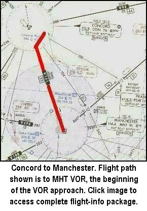
The flight begins at Concord Municipal airport, KCON, Concord, New Hampshire with Manchester, N.H., KMHT, the destination. Click on the image to the left to download the flight-information package, con-mht.zip.
The zip-file includes the IFR chart, the approach plate for VOR Rwy 35 at Manchester, and this text description of the flight.
This flight ends with the simplest VOR approach. You will fly to the VOR, proceed outbound from the VOR, away from the field, make a procedure turn to the left, and return to the VOR, finally descending to the runway.
Do nothing until you have gone through the step-by-step flight details with this text and your charts. Only by doing this will you understand the purpose of each step, but you will visualize them in your mind, a critical part of instrument flight.
- Set the flight simulator weather conditions to 1000 ft overcast, cloud tops at 10,000 ft., and one mile visibility. The wind is calm.
- Move your aircraft to Concord's Runway 35, and retract the flaps to 0°.
- Tune the Nav-2. receiver to the Manchester VOR, 114.4 MHz., ident MHT.
NOTE: Fly this entire Approach with your Nav-2 Receiver for better needle visibility.
- Set VOR-2 OBS to 172°. Reset the timer to zero.
- Takeoff from Runway 35 with a climbing left turn to the southwest. ATC has cleared you to 3000 ft.
- Intercept V141 south-bound, 172° magnetic course indicated by the VOR needle centering and a TO flag showing. Cruise at 110 kts.
- Track inbound to the MHT VOR. Heading will be 172° with no wind.
- On station passage, when the FROM flag appears, turn left to 155° and set the VOR-2 OBS to 155°.
- Start the timer, and track outbound for two minutes.
- During the outbound leg from the VOR, descend to 2000 ft. You probably will have to continue your descent into the procedure turn since you have 1000 ft. to lose.
- After two minutes outbound from the VOR, turn left to the procedure turn heading of 110°. Reset and restart the timer.
- Fly the 110° heading for one minute then make a 180° turn to the right to 290°.
- Set the VOR-2 OBS to 335° the inbound heading to the VOR and to Manchester's Runway 35 and reset the timer, but do not start it yet.
- Intercept the MHT 335° radial with a right turn, and start the timer.
- Descend to 1600 ft., drop one notch of flaps and slow to 75 kts.
- Shortly after two minutes on the timer you will reach station passage at the MHT VOR, indicated by the TO-FROM flag switching to FROM.
- Maintain your heading; don't worry on station passage if the needle slides off the side of the gauge. If you're tracking well it will return to center shortly after station passage.
The purpose of everything that you have done so far is to stabilize the approach before arriving at the FAF, Final Approach Fix. By stabilizing the approach only power adjustments will be necessary to descend or maintain level flight. If you don't stabilize the approach before arriving at the FAF, it's not likely to be satisfactory.
- If there is a crosswind, which is common, the inbound leg from the procedure turn to the FAF is the place to establish the correct WCA, not after passing the FAF.
- On station passage at MHT, when the FROM flag appears, reset and restart the timer, and reduce power to descend to the MDA, Minimum Descent Altitude, of 860 ft.
- Don't chase the needle on station passage. Maintain 75 kts. and proceed outbound from the VOR on the 335° radial towards the runway, remaining level at 860 ft.
- The distance from the station to the runway is 4.3 nm. At 75 kts 3 min., 26 secs. will elapse to cover this distance.
- With one mile visibility you should sight the runway or approach lights at about 2 min, 38 secs. after station passage. Although the runway will lie dead ahead if you have tracked from the VOR well, it is angled 17° to the right. Runway 35's heading is 352° so be prepared to turn to it when you sight it.
- On seeing the runway, further slow the aircraft and configure it for landing. Field elevation is 234 ft so you will have a little over 600 ft to descend to land.
Repeat the flight with the same conditions, but set in a 026° at 26 kts crosswind into your Flight Sim weather page. This will give you a 010° at 26 kts magnetic crosswind. Enjoy the challenge and satisfaction of flying it well.
Remember, the winds in Flight Simulator are Magnetic Direction, not True Direction, so enter your Magnetic Course into the Virtual E6-B Computer along with the 010° at 26 kts wind when calculating Wind Correction Angles, WCA, and Ground speeds.
* * *
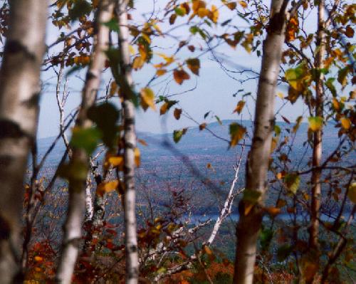
Mt. Monadnock, the second most climbed mountain in the world.
At last, a tranquil flight. Counter had neither reached me on my pager nor through The Boss. I was on my way out of the pilot's lounge at the Gardner, Massachusetts municipal airport, headed to my C182 Nav Trainer to perform the usual early-morning thorough preflight. The jaunty gait to my step pronounced to all my good humor and optimism. I stopped to let the fuel truck pass on its way to a plane that had just taxied in.
When the way became clear again, I couldn't move. Counter was standing beside my plane, a broad grin on his face. At his feet was a mountain of gear, the specifics of it indiscernible from the distance.
"Good Morning!" he shouted.
I responded in kind, if not quite with the same enthusiasm.
"You don't have to deadhead back after all. I have a long weekend free, and want to go to Keene, N.H. then scale Mt. Monadnock," he said as I drew nearer. He spread his hands at the stack of mountaineering equipment at his feet for emphasis.
Even though Mt. Monadnock is the second most-climbed mountain in the world, behind only Mt. Fuji in Japan, the level of difficulty is not high. It peaks at 3165 feet, 1800 feet above the parking lot, with five major, well-cleared and well-marked trails to guide the trekkers. A fit person can make it to the top in under three hours including rest stops.
I looked at Counter's equipment in awe: four stacks lay at his feet:
Clothing
- Two hats, a sun hat and warm hat
- Wind parka w/hood
- Mittens, Camp
- Mittens, Climbing
- Over Mittens
- Wind pants
- Gaiters
- Overboots
- Polarguard jacket and pants
Camping Gear
- A tent
- Sleeping bag and booties
- Thermarest pad
- Bic lighters
- Bowl, cup, spoon
- Tea strainer
- Food
- Alarm wrist watch
- Swiss Army knife
- Tooth brush/Tooth powder
- Hand lotion, Chapstick
- Miniature TV set
Climbing Gear
- Ice ax
- Ice tool w/hammerhead
- Crampons
- Ropes (2 9x50m)
- Prusiks
- Pulleys
- Harness (seat and chest)
- Belay/Rappel device
- Carabiners
- 5 Pickets
- 4 Ice Screws
- Tools for bindings and crampons
- First-aid kit
- Aspirin
Day Gear
- Water Bottles w/insulated cover
- Sun screen
- Sun glasses, Sun hat (baseball)
- Ski goggles
- Camera/Film
- Compass, Maps
Had Counter confused Mt. Monadnock with the 12,380 ft. Mt. Fuji?
One thing about Counter, he never did anything very ordinary. I knew Keene well, with relatives living there. It's the geographic center of New England. The view from Mt. Monadnock's summit is magnificent. On a clear day all six New England states can be seen.
If it had been Halloween, Counter could have participated in another Guiness Book of World Records event: For five straight years more pumpkins were carried into Keene and put on display than anywhere else in the world. Over 17,000 last year.
Counter didn't do his homework well: Keene and Cheshire County are conclaves with the highest density of Democrats in all of New Hampshire. Clinton visited there six times, twice after being elected President. The local organizing committee issued a special button for one of Clinton's appearances: Keene on Hilary. Clinton quipped that he had one of those buttons on his desk in the Oval Office, although it's unclear whether he uttered those words before or after the Monica mess.
The Flight
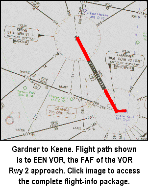
![]() The flight begins at Gardner Municipal airport, KGDM, Gardner, Mass. with Keene, N.H., KEEN, the destination. Click on the image to the left to download the flight-information package, gdm-een.zip.
The flight begins at Gardner Municipal airport, KGDM, Gardner, Mass. with Keene, N.H., KEEN, the destination. Click on the image to the left to download the flight-information package, gdm-een.zip.
The zip-file includes the IFR chart, the approach plate for VOR Rwy 2 at Dillant-Hopkins airport in Keene, and this text description of the flight.
This flight is unusual in that a procedure turn is not required for our route of flight. We proceed from the GDM VOR to EEN VOR and straight in to Runway 2 at Dillant-Hopkins, KEEN.
As usual, do nothing until you have gone through the step-by-step details of the flight with this text and your charts. Only by doing this will you both understand the purpose of each step, but you will visualize them in your mind, a critical part of instrument flight.
NOTE: Fly the Instrument Approach portion with your Nav-2 Receiver for better needle visibility.
- Set the flight simulator weather conditions to 1800 ft overcast, cloud tops at 10,000 ft., and two miles visibility. The wind is calm.
- Move the aircraft to Gardner's Runway 36, KGDM, and retract the flaps to 0°.
- Tune the Nav-1 receiver to the Gardner VOR, 110.6 MHz., ident GDM.
- Set the VOR-1 OBS to 323°. Reset the timer to zero.
- Tune NAV-2 to 109.4 MHz., Keene VOR, ident EEN.
- Set the VOR-2 OBS to 024°, the inbound track to Keene VOR and Dillant-Hopkins' Runway 2.
- Takeoff from Runway 36 with a climbing right turn to 280°. ATC has cleared you to 4000 ft.
- Intercept Gardner's 323° radial northwest-bound, indicated by the VOR needle centering. Cruise at 110 kts.
- Track outbound from the GDM VOR. Your heading will be 323° with no wind.
- Engage the HDG control of the Autopilot to maintain the 323° outbound track from GDM.
- Intercept the 024° radial with a right turn and descend to 2600 ft.
- Slow to 75 kts and drop one notch of flaps. Track inbound to the VOR.
At this point your approach should be stabilized.
- On station passage, when the FROM flag appears, start the timer, and descend to 1600 ft.
- Don't chase the needle on station passage. Maintain your heading and don't worry if the needle slides off the side of the gauge. If you're tracking well it will return to center shortly after station passage.
- Runway 2 is 5.7 nm from the FAF, EEN VOR. Elapsed time to cover that distance at 75 kts will be 4 min., 34 secs.
- With two miles visibility, the runway threshold or approach lights should become visible 2 min., 58 secs. after station passage.
- On sighting the runway, configure the aircraft for landing and make a normal landing. Field elevation is 488 feet so slightly more than 1100 ft must be lost for touchdown from the MDA.
- Runway 2's heading is 019° so a 5° turn to the left to it will be necessary after sighting it.
* * *
![]()
"I know your family has planned the reunion for two years," The Boss said, handing me a sheet of paper. "But this is right on your way—should only take a couple of hours."
I was in The Boss's office and quickly read the document; an e-mail from Mr. Benjamin Counter. It repeated what The Boss had already told me over the phone. Counter had recently learned of a distant relative that had died in an Indian ambush in the late 17th century, and he wanted to get to the site to learn more.
Counter had joined the information age by sending an e-mail. A spark of hope rose in me that he would continue to progress and learn how to plan in the future, rather than "Right now will be OK," when asked 'when did he want to leave?'
Counter's e-mail detailed what little he knew. The time was July 4, 1697 and his relative was in a party of settlers returning home from the Parish of Unity in S. Berwick, Maine. Major Charles Frost was among the group, the apparent target of the ambush. Frost was Military Governor of the Province of Maine, before it broke away from Massachusetts. In a battle during the King William War, Frost and his troops captured 600 Indians, selling some of them in the West Indies as slaves. Others were killed.
The Indians retaliated—and it was successful. Frost was killed, along with two settlers who happened to be in the wrong place at the wrong time.
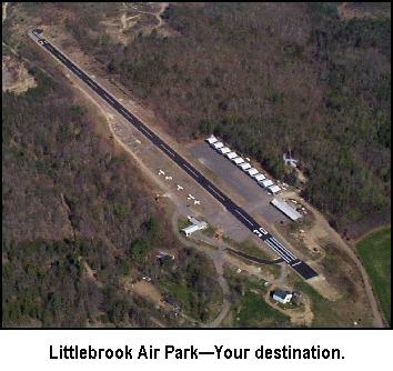
Counter's goal is Littlebrook Air Park, in Eliot, Maine, a five minute drive to "Ambush Rock," where the incident took place. It all happened over 120 years before Maine became the 23rd state. And Counter had to be there "right now!"
"Pick up Counter at Portland's G-A terminal," The Boss said with finality.
I left, wondering what logic made a flight north to Portland then back south with Counter to Eliot "right on my way."
The Flight
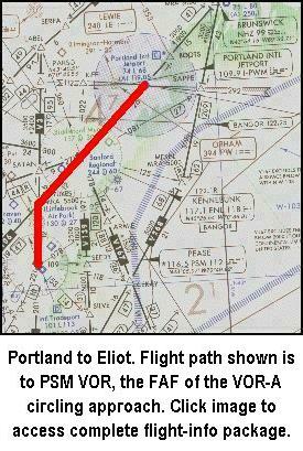
![]() The flight begins at Portland International airport, KPWM, Portland, Maine, with Littlebrook Air Park, 3B4, in Eliot, Maine the destination. Click on the image to the left to download the flight-information package, pwm-eliot.zip.
The flight begins at Portland International airport, KPWM, Portland, Maine, with Littlebrook Air Park, 3B4, in Eliot, Maine the destination. Click on the image to the left to download the flight-information package, pwm-eliot.zip.
The zip-file includes the IFR chart, the VOR-A approach plate for Littlebrook airport in Eliot, and this text description of the flight.
This flight requires a circling approach to Littlebrook's Runway 30, and includes a wind condition to keep the challenge up. There is also a VOR intersection to contend with. The flight proceeds from Sanford to the Pease VOR, PSM, a left procedure turn, return to PSM and track outbound to Littlebrook with a circling approach into the left traffic pattern for Runway 30.
A longer flight was allotted than previous flights to provide time to stabilize the Wind Correction Angles.
As usual, do nothing until you have gone through the step-by-step details of the flight with this text and your charts.
- Set the flight simulator weather conditions to 750 ft overcast, cloud tops at 10,000 ft., and one mile visibility. Set the wind at 29 kts., from 315° (which will be 300° for the wind calculations).
- Recall that winds in Flight Simulator are Magnetic Direction, not True Direction, so enter your Magnetic Course into the Virtual E6-B Computer when calculating Wind Correction Angles, WCA, and Ground speeds.
- Move the aircraft to Portland's Runway 29, and retract the flaps to 0°.
- Tune the Nav.1 receiver to the Kennebunk VOR, 117.1 MHz., ident ENE and the Nav 2 receiver to Pease VOR, 116.5 MHz, ident PSM.
- Set VOR-1 OBS to 242° and VOR-2 OBS to 200°. Reset the timer to zero.
- Takeoff from Runway 29 with a climbing left turn to intercept V93, the 242° radial to ENE VOR.
- Climb at 90 kts. to your cruise altitude of 4000 ft. The WCA will be 16° Right for climb.
- Plan a 110 kt. cruise speed. With a 29 kt. wind from 300 the WCA will be 13° Right.
- Set the proper Wind Correction Angle based on air speed, then engage the autopilot heading control for that heading.
- On station passage of ENE, when the FROM flag appears, continue outbound on same course, but the airway becomes V106.
- Intercept YUKES intersection of V106 and V3, indicated by centering of the VOR-2 needle with a TO flag showing.
How do you know whether you have passed an intersection? It's easy. When the needle is on the same side of the gauge as the station is to the aircraft, you have not arrived at the intersection.
But remember, intersections are determined by FROM radials. The radial FROM PSM to establish YUKES intersection is 020°. With the VOR tuned to PSM, and with the OBS set to 020° we have not reached the intersection as long as the needle is deflected to the left, which is the side of the aircraft that the station is on.
But we have set the OBS for PSM to 200°, the reciprocal of the radial, the TO direction because we are going to intercept that radial and fly to the station. Setting the OBS to the reciprocal of the radial, and with the TO flag showing, reverses the rule. We have not reached the intersection as long as the needle is deflected away from the side of the aircraft that the station is located, or to the right in this case.
- Turn left at YUKES and track inbound to the PSM VOR, magnetic course of 200°. The Wind Correction Angle will be 15° Right. Set the autopilot heading control on if desired.
- NOTE: From this point on fly the rest of the route using VOR-2. This VOR is easier to read with no Glideslope needle.
- Descend to 3000 ft. during this southbound leg.
- At station passage of PSM, when the FROM flag appears, turn right to 232°, set the OBS to 232°, start the timer and fly outbound for two minutes. The WCA will be 14° Right.
- At two minutes, turn left to 187° into the procedure turn. Reset and restart the timer. The WCA will still be 14° Right.
- At one minute turn right to 007° The WCA should be 14° Left. Set the OBS to 052° the inbound heading to PSM VOR and to Littlebrook Airport.
- On intercepting the 052° radial turn right to track to the PSM VOR. Start the timer and descend to 1500 ft.
- After two minutes or so expect station passage. The WCA inbound will be 14° Left at 110 kts.
- Slow to 75 kts, and drop one notch of flaps. Readjust the WCA to 21° Left at 75 kts. to keep the needle centered at this reduced speed. Use the autopilot heading hold, if desired, inbound to the VOR, but at station passage of PSM VOR switch the autopilot off and manually fly the remaining portion of the approach and landing.
At this point your approach should be stabilized, especially your compensation for the strong wind from the left.
- At station passage, when the FROM flag appears, reset and restart the timer and descend to the MDA of 720 ft. Your ground speed will be 81 kts. Time to cover the 4.3 nm to the field at 81 kts. will be 3 min., 11 secs.
- With one-mile visibility, expect to sight the field at 2 min., 27 secs. after station passage of PSM VOR. Field elevation is 130 ft.
- On spotting the field, enter a left downwind leg of 125° (WCA of 2° Right). The left base leg will be 035° with a WCA of 23° Left. Be aware that your ground speed on final approach will only be 46 kts. into the teeth of the wind, so moderate your rate of descent to avoid an embarrassing last-minute burst of speed to prevent an early landing.
- Note that The landing threshold of Runway 30 is displaced 86 ft. Don't touchdown early.
After the flight reward yourself with a cup of coffee for a job well done. Instrument approaches don't get much tougher than this one
* * *
![]() I love the morning and arrived at the airport early, as usual, before anyone else. Started the coffee and relaxed in the pilots lounge.
I love the morning and arrived at the airport early, as usual, before anyone else. Started the coffee and relaxed in the pilots lounge.
The phone rang in the outer office. Still by myself I went out and picked it up.
"Charter Service," I answered.
"Good morning," a beautiful female voice began. "Am I speaking with the Executive Charter Pilot?"
With that voice, I was willing to be anything she wanted. "Yes, Ma'am," I answered in my sunniest voice.
"Good, I'm Cheryl, Mr. Counter's Administrative Assistant. He's on Block Island and asked me to contact you about a flight to North Kingstown, Rhode Island. He was feeling very nostalgic last night about what drive's him, about what gives him the motivation to arise each morning and fight off the swarming alligators." After a pause, she said rather apologetically, "His words."
"Of course we can help," I responded. "What time this morning does Mr. Counter want to be there?" I asked trying very hard to keep the sarcasm from my voice.
"He said it didn't matter," She answered. "Anytime between 9:00 AM and 10:00 AM would be OK."
"Must be pretty important," I said, shaking my head sadly.
"Oh, it is," she responded quickly. "Mr. Counter wants to visit the birthplace of Gilbert Stuart, the man whose work so inspired him."
The name meant nothing to me. "Is Mr. Stuart famous?" I asked.
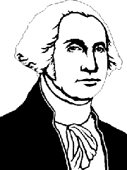
"Oh, yes," Cheryl enthused. "He's the famous artist that painted George Washington's portrait that you see hanging everywhere. And he painted the portraits of four other presidents, too, plus British Kings George III and George IV.
"I'm sure Stuart's work is awesome, but I'm missing the connection with the motivation that drives Mr. Counter," I said rather puzzled.
"Oh, Silly," Cheryl said with a laugh, "Stuart did the portrait that's on every one-dollar bill."
The Flight
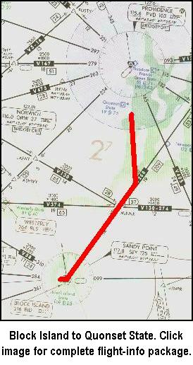
![]() The flight begins at Block Island State airport, KBID, Block Island, Rhode Island, with Quonset State airport in North Kingstown, KOQU, Rhode Island the destination. Click on the image to the left to download the flight-information package, sey-oqu.zip.
The flight begins at Block Island State airport, KBID, Block Island, Rhode Island, with Quonset State airport in North Kingstown, KOQU, Rhode Island the destination. Click on the image to the left to download the flight-information package, sey-oqu.zip.
The zip-file includes the IFR chart, the approach plate for VOR Rwy 34 at Quonset State airport in North Kingstown, and this text description of the flight.
You wanted a VOR approach where the Omni was off the field? Well, not only is this VOR some 8 nm. off the field, but it is past the field. This approach introduces the concept of an FAF identified by the intersection of two VOR radials. A procedure-turn is not required for our route of flight and entry into the approach.
The flight proceeds from the 046° radial of Sandy Point VOR, SEY, at Block Island, intercepts the 186° radial of Providence, PVD, then straight in to Quonset's Runway 34.
You'll be a little busy on this approach, but it's a piece of cake compared to the last one.
As usual, do nothing until you have gone through the step-by-step details of the flight with this text and your charts.
NOTE: Fly the Instrument Approach portion with your Nav-2 Receiver for better needle visibility.
- Set the flight simulator weather conditions to 900 ft overcast, cloud tops at 10,000 ft., and two miles visibility. The wind is calm.
- Move the aircraft to Block Island, KBID, Runway 28, and retract the flaps to 0°.
- Tune the Nav-1 receiver to the Sandy Point VOR, 117.8 MHz., ident SEY.
- Set the VOR-1 OBS to 046°. Reset the timer to zero.
- Tune the Nav-2 receiver to 115.6 MHz., Providence VOR, ident PVD.
- Set the VOR-2 OBS to 006°, the inbound course to the VOR and Runway 34 at Quonset State airport.
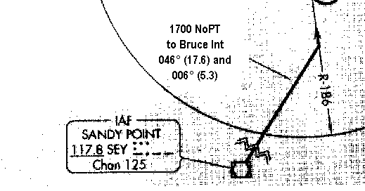
This note on the approach plate explains that if you fly the SEY 046° radial at an altitude of 1700 ft and intercept the PVD 006° radial TO the station, you may enter the approach procedure without having to perform a procedure turn.
- Takeoff from Runway 28 with a climbing right turn and intercept V268, the 046° radial from SEY VOR. The SEY VOR is the IAF, Initial Approach Fix, for the approach.
- For such a short flight you'll cruise at the 1700 ft. initial approach altitude for Quonset State. Climb at 90 kts.
- When you are satisfied with the VOR outbound track, engage the autopilot heading control to maintain the magnetic course of 046°.
- When the VOR-2 needle centers, indicating an intercept of the 006° radial TO PVD, turn left to 006°.
- When properly tracking inbound on the 006° radial, reengage the autopilot to maintain the heading.
- Tune the Nav-1 receiver to 110.0 MHz., the Norwich VOR, ident ORW.
- Set the VOR-1 OBS to 110° to identify BRUCE intersection when the needle centers and a FROM flag is showing.
- Reduce your speed to 75 kts., and drop one notch of flaps.
At this point your approach should be stabilized.
- Fly to the BRUCE intersection. Remember, with the needle on the same side of the gauge as the station is to the aircraft—to the left in this case—you have not yet arrived at the intersection.
- BRUCE intersection is the FAF for the approach to Runway 34. When the VOR-1 needle centers, you're there. Start the timer.
- Descend to 660 ft.
- Time to fly the 5.1 nm. from the FAF to the MAP at 75 kts. is 4 min., 05 secs.
- With two-miles visibility you should spot the approach lights or Runway 34 threshold in 2 min., 29 secs.
- On sighting Runway 34, land normally.
This concludes the session on VOR approaches for the situation where the VOR is located some distance from the field.
Fly each approach a second time, to hone the techniques, before moving to the next section.
Click on the Approaches—VOR on the Field button to move to the next type of VOR instrument approaches, where the VOR station is on the field.
Site best viewed at 600 × 800 resolution or higher.
© 1999 – 2002, Charles Wood.