VOR Navigation
Part III
Benjamin Counter returns
My cellphone rumbled. I glanced about at the nearby diners all of whom had grown silent at the sight of my cellphone. "Yes?" I whispered into the mouthpiece.
"I want to get to Concord first thing in the morning," the voice boomed from the other end. It was Counter.
In the past he called the Boss when he wanted to charter. Then he got my home-phone number and called me direct. The Boss had told me to accommodate Counter whenever it was feasible. He'd bill him later. Now Counter had my cell number. What was next?
"Concord?" I asked rather foolishly.
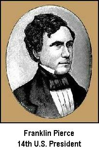
"Yeah, I'm at Pease Int'l. Tradeport in Portsmouth and saw your plane parked by the General Aviation terminal. I have to get to Concord to thank President Franklin Pierce," he answered.
That really set me back. Pierce, our 14th President, had died in 1869. "I don't believe he'll be able to see you," I wise-cracked.
"Don't be funny," Counter rejoined. "Eight-A.M. at the airport," and he hung up.
What did Counter have in common with Pierce, I wondered? A quick look on the Internet later was of little help. A Democrat and our most obscure President, Pierce was from Concord, N.H. Did Counter hate lawyers? Pierce was oft quoted from his inaugural speech, "In a body [like Congress] where there are more than one hundred talking lawyers, you can make no calculation upon the termination of any debate."
No, there had to be something more. Then it started to come to me. Pierce was a 'Northerner with Southern principles.' He favored slavery which so angered his followers that many broke away and formed the Republican Party. Counter wanted to thank him for his contribution to the formation of the Republican Party.
Pierce's popularity wasn't helped by the Whig opposition's campaign rhetoric: "Hero of many a well-fought bottle."
I set my alarm and went to bed.
The Flight, KPSM to KCON
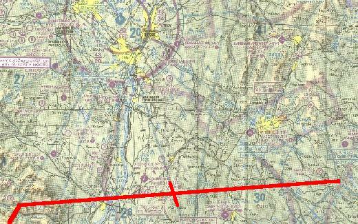
Your flight is from Pease Int'l Tradeport, Portsmouth, N.H. to Concord (N.H.) Muni Airport. A strong cold front came through a few hours ago, leaving crystal-clear skies and a very strong wind of 28 kts. from 345°. You will depart from Runway 34, intercept the Concord 119° radial and land at Concord on Runway 35. The distance between the two cities is 31 nm. Pease field elev. is 98 ft., and Concord is at 344 ft. Cruise at 4500 ft. Flight time is about 22 minutes.
Before departure, set your Nav 1 receiver to 112.90 MHz, and the OBS to 299°—the reciprocal of the CON VOR 119° radial. Be aware that the CON VOR is about 3.5 NM past the field if you are tracking the distance from Pease with your DME. Set a 28 kt wind from 360° into your Flight Simulator weather page. This will give you your 345° wind (FS2000 and FS2002).
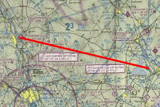
Pease to Concord. Click image for full size.
Where am I?
With the plethora of Navaids dotting the landscape these days, it's getting harder and harder to get lost. But we pilots are an ingenious lot. No matter how closely the FAA, or its equivalent in other countries, spaces Navaids to protect us against ourselves, we continue to outwit them. We don't get lost, of course. Pilots simply don't get lost—it's just that none of the landmarks within the range of our vision happen to be on our chart. We certainly intend to talk to the authorities about these poorly-marked charts once we land, that is if we can find the correct airport—or any airport.There is hope. With a VOR receiver fixing one's location takes only moments.
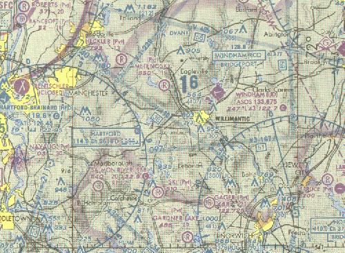
We're somewhere on this section of the chart. Click image for full size.
We locate our position by triangulation. We'll use the Hartford, HFD, 114.9 MHz VOR to the west and the Norwich, ORW, 110.0 MHz VOR to the east as our reference points.
Select either HFD or ORW as your first reference, it makes no difference. We'll use Hartford.

The Nav receiver is set to the HFD VOR, 114.9 MHz, the ident switch is on, and we've rotated the OBS until the needle is centered with the FROM flag showing. The index card and digital readout shows that we are on the 065° radial from HFD. Remember, the aircraft heading does not affect determining the radial from a VOR if you center the needle with the FROM flag showing.
You can prove this to yourself on your Flight Simulator. Position your aircraft within receiving range of any VOR, but not too close, then determine the radial from the VOR by centering the needle with the FROM flag showing, and then fly the aircraft in any heading, observing that the needle doesn't significantly change other than the normal movement from crossing radials.
With this information, we'll draw the 065° radial from HFD on the chart.
We're somewhere on the 065° radial of HFD. Click image for full size.
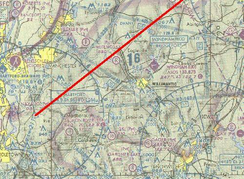
Now repeat the procedure using the Norwich VOR.
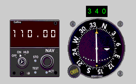
The Nav receiver is set to the ORW VOR, 110.0 MHz, the ident switch is on, and we've rotated the OBS until the needle is centered with the FROM flag showing. The index card and digital readout shows that we are on the 340° radial from ORW.
With this information, we'll draw the 340° radial from ORW on the chart.
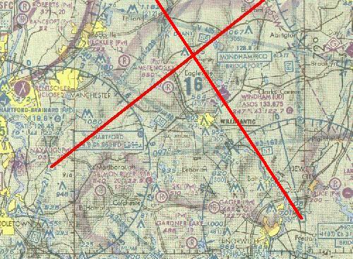
See, Pilots don't get lost—we're at the intersection of the two radials.
Click on the image for full size.
Important Note: One obtains the greatest position accuracy when the angle between the two reference VORs is 90°. In this case, the angle is 085° (065° – 340° which becomes 065° + 20°).
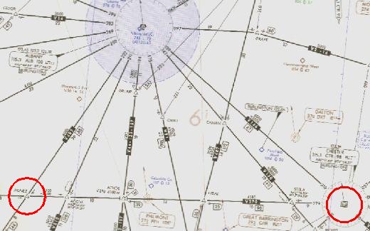
Where am I on the Airway?
The procedures just described are useful if a pilot becomes disoriented or lost, but hopefully that is a very infrequent experience. A much more common situation is the desire to locate your position along a Victor airway when it is a long distance between VORs or to an intersection. This is especially true when flying IFR and ground features are not visible.
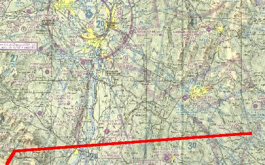
Route of flight, V270 to V489. Click image for full size.
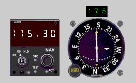
The Nav receiver is tuned to Albany VOR, 115.3, ident switch is on, and the needle has been centered on the 175° radial from ALB. Since we are flying on V270 we needn't draw the full radial down from Albany VOR—just a tick mark where it crosses our flight path will show where we are.
There we are, at the intersection of the two radials. Click image for full size.
IFR charts are useful for more than just IFR flights. Consider the Chester to AGNEZ route via V270 on chart L-25. Notice how many intersections there are along the route. These are convenient checkpoints during a flight. The radials are already printed on the chart, it's simply a matter of tuning in Albany VOR on 115.3 MHz, and setting the OBS for the appropriate radial, making certain that the FROM flag is showing. Then you can map your progress along V270 from Chester to AGNEZ intersection, at which point the flight plan requires a left turn to intercept V489.
There's even an NDB immediately on the flight path so that's one more checkpoint of your progress. Just tune the ADF to 272 KHz, Philmont, PFH and note station passage.
Your next flight will be Chester to AGNEZ. Fly it with the IFR chart. Click here to download the 300 dpi file of the section of the IFR chart needed for the flight. Unzip it and print it full size with the minimum margins that your printer allows.
IFR chart showing V270, Chester to AGNEZ. Click image for full size.
The flight will begin at Barnes Muni Airport, KBAF, in Westfield, Mass., 13 nm southeast of Chester VOR. Intersections will be from Albany VOR, 115.3 MHz.
- Set 30 kt wind from 164° into your flight simulator. This results in an actual 30 kt wind from 150° for FS2000 and FS2002.
- Using your virtual E6-B, calculate WCA for this 30 kt wind from 150°, cruise at 110 kts, magnetic course; 279°.
- Tune Nav to Chester VOR, CTR, 115.1 MHz.
- Take-off from Barnes Muni Airport, KBAF, Runway 15. Turn left then direct to Chester VOR. Reset timer.
- Climb to 4000 ft.
- At Chester VOR, intercept V270 westbound. Start Timer.
- Apply calculated Wind Correction Angle.
- Cruise at 110 kts IAS.
- Log the time when passing the following intersections:
- STELA
- ATHOS
- ACOVE
- AGNEZ
- Terminate flight after passing AGNEZ—Stop Timer.
- Calculate Average Ground Speed from Chester VOR to AGNEZ Int. (56 nm)
Benjamin Counter's unlikely friend
The convention was nearing its end after two days of updates and seminars on issues affecting charter pilots. Tonight's formal dinner-dance nicely capped everything off. I was in my hotel room struggling with my bow tie—real, not clip-on, when a knock sounded on the door. I glanced at my watch, congratulating myself on knowing the perfect corsage arrangement to compliment my companions gown.
I called to the delivery person to bring in the flowers and froze when an all-too familiar voice boomed "Good evening!"
It was Counter.
"I see were just in time," he went on before I could utter a word.
"We are?" I said in amazement.
"Yes," Counter replied, a broad grin on his face. "You wont need the bow tie or the monkey suit—we have to leave in forty-five minutes to get to the meeting on time."
"I have other plans tonight," I said, returning to the task of tying my bow tie.
"The Boss said you might say some nonsense like that—told me to tell you to call him if you had any problem doing the charter. Said something about seminars being a waste of time and money, anyway" Counter finished.
"Where we going?"
"Worcester—theyre doin a special memorial on a classmate of mine—Abbie Hoffman."
I was stunned. "The Abbie Hoffman," I asked, "of the Chicago Seven?".
"Yes, of course," Counter replied, confused that I would ask. "Is there another?"
I looked at Counter again. Yeah, he was about the right age.
Abbie Hoffman, the leader of the Yippies, Youth International Party, organized the nation's youth through media stunts. He had been in Chicago to disrupt the 1968 Democratic Convention in protest of the Vietnam War. Among other things, he had pledged to spike the entire city's water supply with LSD. It was technically an impossible feat, but nonetheless the city surrounded the reservoir with armed guards.
The anti-war demonstrations became violent and Hoffman, with other leaders, was arrested, leading to the famous Chicago Seven trial. He went underground but ultimately was imprisoned. Following his release he became increasingly unstable and committed suicide in 1989.
I looked at Counter again, wondering what this business leader could have in common with Abbie Hoffman. Because of all of the acid and drugs that had been done during those years the Hippies' famous underground slogan came back to me:
you weren't really there!
I glanced at my watch again. Leaving now, I could still be back in time for dessert and the dance. "I have a phone call to make and we'll go," I said, reaching for the phone.
The Flight, KOQU to KORH
This flight, from Quonset State Airport, KOQU, in North Kingstown, R.I. to Worcester, Mass., KORH, puts everything together learned so far on VOR navigation. Your cruise speed will be 110 kts, and climb at 90 kts. Total distance is 56 nm. It's a fun flight because you stay busy. Here are the details: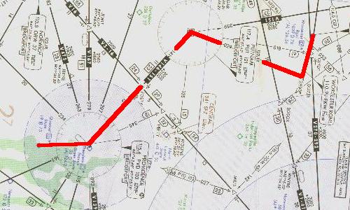
Quonset to Worcester (chart is turned 90°). Click image for full size.
Click here to download the 300 dpi file of that part of the IFR chart needed for the flight. Unzip it and print it with one-inch (2.54 cm) printer margins.
NOTE: Use a Flight Log for this flight. Details immediately follow the flight description.
- Departure is from Rwy 34, Quonset State Airport, KOQU, just south of Providence.
- Fly inbound to PVD VOR, 115.6 MHz, climbing to 4000 ft. Distance = 7 nm.
- At PVD VOR intercept V146 NW, fly the 321° radial inbound to PUT VOR, 117.4 MHz. Distance = 23 nm.
- At PUT VOR turn NE, fly the 029° radial outbound, to the GOZZR Intersection. Distance = 19 nm.
- During the PUT to GOZZR leg, descend to 3000 ft, but no lower.
- Turn left at GOZZR Intersection and intercept the Rwy 29 localizer, 110.9 MHz, to Worcester Regional Airport. When tuned to a localizer frequency the left-right needle is four times as sensitive as when tracking a VOR, i.e., 0.5° per dot.
- Also note that when tuned to a localizer, the OBS is inoperative. Smart pilots rotate the OBS to the localizer heading (in this case 289°) as a visual reminder of their magnetic course after intercepting the localizer. This makes them aware of the intercept angle and how early to begin the turn towards the final heading.
- Track the localizer inbound, descending and landing on Rwy 29. Be alert, Worcester field elevation is 1009 ft. Distance = 6 nm.
- 9. Total flight time: about 30 minutes.
Flight Log
From this flight on, KOQU to KORH, you should complete a Flight Log prior to starting any flight. You must first complete the worksheet described earlier in the "Plotting a Course" section under Air Navigation.Calculate the Ground Speed and time en route for each leg of this flight. For this flight, there is no wind, so the Ground Speed will be the same as the TAS, True Air Speed.
Then complete the Flight Log. Click here to view and print blank flightlog sheets.
After flying the route, set a 30 kt wind from 305° into your Flight Simulator. This will give you a 30 kt wind from 290° in FS2000 and FS2002 for this route. Recalculate the Ground Speed, the Wind Correction Angle and the time en route for each leg with the 290° wind. Use the virtual E6-B for these calculations.
Note that the magnetic course is already determined for this flight because it is the TO or FROM radial of the respective VOR.
Remember, in Flight Simulator do all your wind calculations based on magnetic North. That is the way that FS presents the information on your monitor ... Shift-Z will show your winds. To obtain a certain wind direction, add the magnetic variation to the desired wind direction before entering it into the FS Weather Page.
Now re-fly the course. Do it without using the autopilot and enjoy the challenge.
Click on the VOR Approaches button to get into the soup and see if you can find the runway at your destination.
Site best viewed at 600 × 800 resolution or higher.
© 1999 – 2002, Charles Wood.